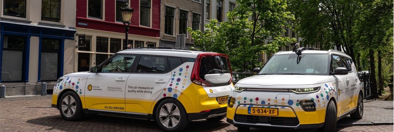
Air View Mobile Platform
Two laboratory-grade measurement cars from Utrecht University's IRAS drive city streets recording nitrogen dioxide, soot, particulate matter, and ultrafine particles every second. The resulting high-resolution maps reveal street-by-street pollution variation across European cities, informing healthy cycling routes, urban planning decisions, and epidemiological research on air pollution and health.
The Air View Car — Mobile Urban Air Quality Monitoring
Utrecht University’s Institute for Risk Assessment Sciences (IRAS) operates two Air View Cars that map street-level air quality across European cities with laboratory-grade precision. Unlike fixed monitoring stations, which capture the temporal variation of air pollution, the cars can measure on many streets and generate millions of data points per campaign. This mobile approach produces high-resolution, street-by-street pollution maps that would be impossible to achieve with stationary infrastructure alone.
Instrumentation
Each car carries a suite of complementary instruments covering the major dimensions of urban air pollution:
- CAPS NO2 Monitor (Aerodyne)— uses Cavity Attenuated Phase Shift spectroscopy to measure nitrogen dioxide (NO₂) every second. Its fast response time is essential for mobile monitoring, where concentrations can change sharply within metres as the car passes junctions, loading bays, or heavily trafficked corridors.
- EPC 3783 (TSI) — counts individual ultrafine particles down to approximately 3 nm in diameter. This instrument is central to the project’s focus on ultrafine dust, for which no European regulatory limits currently exist despite growing evidence of health impacts. The water-based design avoids the use of organic solvents, making it well suited to continuous field operation.
- AE33 Aethalometer (Magee Scientific)— measures black carbon (soot) concentrations every second using optical light absorption across seven wavelengths. This multi-wavelength capability allows the instrument to distinguish between soot from fossil fuel combustion (predominantly traffic) and biomass burning, providing source attribution alongside concentration data.
- DustTrak DRX (TSI)— measures fine particulate matter (PM2.5), the size fraction regulated under European air quality standards and most strongly associated with cardiovascular and respiratory disease in the epidemiological literature.
- Partector Pro 2 (Naneos) — measures lung-deposited surface area (LDSA) and particle number size distribution, capturing how particles of different sizes are likely to deposit in the respiratory tract. This goes beyond simple particle counts to provide a health-relevant characterization of the aerosol.
From Data to Impact
Together, these instruments capture the full spectrum of urban air pollution. The data are processed by IRAS into actionable hyperlocal maps that municipalities, urban planners, public health services, and researchers use to design healthier cities: routing cycling and walking infrastructure away from pollution hotspots, positioning green buffers such as hedgerows near schools and playgrounds, and providing the exposure data needed for epidemiological studies linking air quality to mortality, cardiovascular disease, and neurodegenerative outcomes.
Core Capabilities
- Street-level mapping of NO₂, black carbon, PM2.5, ultrafine particles, and lung-deposited surface area
- Continuous street-by-street measurements, millions of data points per campaign
- Source attribution: distinguishes traffic vs. biomass burning emissions
Unique Assets
- Two fully equipped laboratory-grade mobile monitoring cars
- Only mobile platform in the Netherlands measuring ultrafine particles (currently unregulated in Europe)
- Integrated data pipeline from raw sensor output to validated hyperlocal city maps
- Track record across 10+ European cities since 2019
Typical Users
- Municipal health services and urban planners designing low-emission zones or green buffers
- Epidemiologists linking hyperlocal exposure to health outcomes (mortality, cardiovascular, neurological)
- Architects and area developers optimising building placement and public space
- Researchers needing high-resolution exposure data for cohort studies
Access
- Available for collaborative research projects across European cities
- Data outputs include georeferenced pollution maps suitable for GIS integration and epidemiological linkage
Let’s connect!
General InquiriesJules KerckhoffsJ.Kerckhoffs@uu.nl Visiting address:Institute for Risk Assessment Sciences // Yalelaan 23584 CM Utrecht
Facility features:
- Two laboratory-grade mobile monitoring cars for high-resolution, street-level air quality mapping across urban environments.
- Real-time measurement of NO₂, black carbon, PM2.5, ultrafine particles and lung-deposited surface area.
- Second-by-second data collection for up to 8 hours per day, generating millions of data points per campaign.
- Integrated data processing into validated, georeferenced pollution maps for GIS use, urban planning and epidemiological research.